Explore the impacts and preparations surrounding Typhoon Mawar, including power outages, wind speeds, and rainfall records in the Mariana Islands. Discover the measures taken by authorities and the response to the storm. Stay informed about the latest updates and developments related to this powerful tropical cyclone.
Source: wikipedia.org
Super Typhoon Mawar, also known as Super Typhoon Betty in the Philippines, is an extremely powerful tropical cyclone that recently moved away from Guam. It is the second named storm and the first typhoon of the 2023 Pacific typhoon season. Mawar originated from a low-pressure system located south-southwest of Chuuk Lagoon and developed into a tropical depression on May 19. It underwent fluctuations in intensity and eventually strengthened into a Category 4 typhoon on the Saffir-Simpson Hurricane Wind Scale.
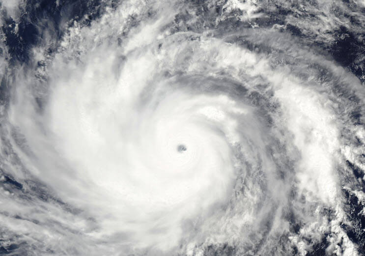
During its development, Mawar completed an eyewall replacement cycle, resulting in the formation of a uniform eye. According to the Joint Typhoon Warning Center (JTWC), Mawar achieved 1-minute sustained winds of 160 knots (295 km/h), equivalent to a Category 5-equivalent super typhoon.
On May 24, Typhoon Mawar passed just north of Guam as a Category 4 storm. It brought hurricane-force winds and heavy rainfall, making it the most powerful storm to impact the island since Typhoon Pongsona in 2002. The strong winds caused power disruptions on Guam starting from May 22 as the storm approached the area.
Meteorological history
On May 17, a weak low-level circulation (LLC) was identified by the Joint Typhoon Warning Center (JTWC) located 865 km (535 mi) south of Guam. It was designated as Invest 97W. Forecast models indicated that the disturbance had the potential to develop into a tropical cyclone in the following days. The atmospheric convection expanded over the LLC on the next day, prompting the JTWC to issue a Tropical Cyclone Formation Alert as thunderstorms became more widespread and organization improved.
The Japan Meteorological Agency (JMA) also started tracking the system, initially labeling it as a low-pressure area and later upgrading it to a tropical depression on May 19. The system moved northward due to weak trade winds. Following suit, the JTWC designated it as 02W after the depression had strengthened due to warm waters and favorable outflow patterns. It was then upgraded to a tropical storm as scatterometer data revealed winds of 65 km/h (40 mph) in the southwest quadrant and a central dense overcast formed. The JMA named the storm Mawar.
By May 21, both the JMA and JTWC upgraded Mawar to a typhoon as deep convection completely obscured the low-level circulation center. An eye began forming under the central dense overcast on May 22 as rainbands wrapped around the system’s center.
On May 23, Mawar rapidly intensified, reaching winds of 210 km/h (130 mph), equivalent to Category 4 strength on the Saffir-Simpson hurricane wind scale (SSHWS). It also underwent an eyewall replacement cycle. The typhoon further strengthened and became a super typhoon, reaching winds of 250 km/h (155 mph), the highest classification according to the JTWC. The circulation center became cloud-filled as the system weakened during the eyewall replacement cycle.
On May 24, Mawar passed just north of the northern tip of Guam as a Category 4 typhoon, slightly weakening in the process. By May 25, the eyewall replacement cycle was completed, and a uniform eye appeared. The storm cleared out the initially cloud-filled eye and continued to slowly strengthen as it moved west-northwestward. According to the JTWC, Mawar attained 1-minute sustained winds of 160 knots (295 km/h), equivalent to Category 5 strength on the SSHWS.
Preparations : Mariana Islands
A typhoon watch was issued for the Mariana Islands on May 21 as Typhoon Mawar approached. A flood watch was also issued for the islands. In response, Guam Governor Lou Leon Guerrero and Rear Admiral Benjamin Nicholson set the Condition of Readiness at level 3 (COR 3) while Mawar was still a tropical depression located south-southeast of Guam. Military installations on Guam began securing facilities, and the US Coast Guard evacuated two vessels stationed on the islands out to sea.
Later that day, COR 2 was declared, leading to the closure of courts and public schools, and the suspension of nonessential services. Hospitals and clinics also curtailed their services. Neighboring islands such as Rota and Saipan closed establishments in preparation for the typhoon, and all public schools in the Northern Mariana Islands were closed starting on May 22. Flights to Guam were canceled, and the SCLC caging playoffs were suspended.
On May 22, Governor Leon Guerrero declared a state of emergency for Guam, emphasizing the significant threat Mawar posed to the island. President Joe Biden approved emergency declarations for Guam and the Commonwealth of the Northern Mariana Islands, enabling the allocation of federal resources to support the threatened islands.
On May 23, COR 1 was implemented for Guam, and Governor Leon Guerrero issued an evacuation order for low-lying coastal districts, including Hågat, Humåtak, Malesso, and Talo’fo’fo. Residents were directed to evacuate to higher ground, with the Guam National Guard assisting in the evacuation efforts. The Guam Department of Education opened emergency shelters at 12 schools, and government-operated shelters housed 862 people by 9 p.m. Military installations also authorized the evacuation of individuals in threatened areas.
Preparations : Philippines
In the Philippines, the government took measures to prepare for the possible landfall of Typhoon Mawar. The Department of Social Welfare and Development (DSWD) pre-positioned a total of 689,885 family food packages across the country to ensure adequate supplies for affected areas. The Department of Public Works and Highways (DPWH) began preparing their staff and equipment to respond to the potential effects of the typhoon.
President Bongbong Marcos stated that funds and food supplies had been set up, and emergency teams were on standby to provide assistance as needed. As a precautionary measure, classes were suspended in some areas on May 26 to ensure the safety of students and prevent any disruptions caused by the typhoon.
Impact: Mariana Islands
Typhoon Mawar had significant impacts on the Mariana Islands, specifically Guam. Power outages were reported on Guam starting from May 22 as the winds from the typhoon intensified. Guam International Airport recorded winds of up to 104.7 miles per hour (168.5 km/h) during the storm’s impact.
According to the Weather Prediction Center, multiple locations in Guam received at least 20 inches (51 cm) of rainfall during Typhoon Mawar, with most of it falling in just three hours. The highest recorded rainfall was measured at 28.42 inches (72.2 cm) in Dededo, Guam, according to a rain gauge operated by the United States Geological Survey.
Unfortunately, the typhoon also resulted in two individuals being swept out to sea in separate incidents off Guam on May 25. Despite ongoing search and rescue efforts, they remain missing.
