What is desert? What are the kinds of deserts, Information on deserts of dryness and cold, the climate, landforms.
Desert; any area that, because of dryness or cold, may be characterized as having low potential as a human habitat. Specifically, the term is applied to two kinds of areas: (1) most commonly, areas with arid climate, sparse vegetation or no vegetation, angular landforms, and an absence of full-flowing rivers; and (2) the lands on the polar fringes of the Northern Hemisphere continents and the ice-covered wastes of Greenland and Antarctica. These two kinds of deserts may be spoken of as deserts of dryness and deserts of cold. Deserts of dryness cover about 18% of the earth’s land areas, and deserts of cold cover 16%.
Source: pixabay.com
DESERTS OF DRYNESS
Deserts of dryness are found wherever precipitation is regularly too light to support either a forest or a complete grass cover. The different kinds of dry deserts are characterized by particular combinations of climate, native vegetation, landforms, water features, and soils. The ways in which man has come to use these areas are likewise distinctive.
Dry deserts are systematically distributed over most of the world. Typically, they occur on continental west coasts between approximately 20° and 30° of latitude in both the Northern and Southern hemispheres. From this location, they extend inland, curving toward the poles to reach into the higher middle latitudes in the continental interiors. This generalized position should not be considered precise, principally because of interruption by mountains and because of the detailed direction of coastlines. The generalized distribution of deserts is the result, primarily, of the circulation of the earth’s atmosphere. Either the winds are offshore and hence bring no rain, or they have traveled so far from a water source that no moisture remains in them to be condensed and precipitated.
Climate:
The outstanding features of all desert or arid climates are meagerness and uncertainty of precipitation. The amount of rain does not equal the potential evaporation. Even the small- amount that does fall is subject to great variation from year to year. Rain comes at infrequent and irregularly spaced intervals in all areas of arid climate. Generally, there is no definite season of rains, and widespread rain is uncommon. Storms are localized so that effects are not felt over any considerable area. Months or even years may pass between storms; but when they do occur they are often so violent as to cause extensive damage to any of the works of man. The few, normally dry stream channels fill rapidly to overflowing, destroying villages and oasis gardens lying near them. On the other hand, the storms replenish the scanty supplies of groundwater that make life possible in the desert. On the occasion of a very rare gentle shower, the rain barely moistens the surface and is soon evaporated. At times, clouds form, and one can see rain beginning to fall from them, only to be re-evaporated before it reaches the ground. Thus an average yearly precipitation figure is almost meaningless. It can only suggest meagerness. The uncertainty and irregularity of precipitation in desert areas must be understood, as well.
Temperatures within arid climates vary all the way from those characteristic of the tropics to those of the high latitudes. The only common element is great range, both annual and daily. In the low latitudes, the difference between the coolest and warmest months amounts to 15° to 30° F (about 8° to 17° C); in the middle latitudes, the yearly range usually amounts to 40° to 50° F (22° to 28° C). Where arid climates extend to continental west coasts, as they do near the margins of the low latitudes, relatively low temperatures and annual ranges are encountered as a result of the presence of offshore cold ocean currents in these latitudes.
Daily temperature ranges are usually large in most deserts. In the low latitudes and on the margins of the tropics have been recorded the highest air temperatures known anywhere in the world. Azizia, southwest of Tripoli in Libya, has registered a shade temperature of 136.4° F (58° C). Even higher air temperatures have been reported unofficially from northeastern Ethiopia, and Death Valley in California has reported fractionally over 134° F (56.7° C). At Wadi Haifa on the Nile River in the Sudan, 100° F (37.8° C) has been reported in every month except January, and that month has had a maximum of 99° F. In the Australian desert, temperature has risen over 100° F for over 60 days consecutively. At Yuma, Ariz., during one summer, the daily maximum passed 100° F in 79 out of 80 days. In spite of very high daytime temperatures, those at night may be very low. The oasis of In-Salah in the central Sahara has had a range of 100° F (55.5° C) within a 24-hour period: from 126° to 26° F (52.2° to — 3.3° C). On Christmas Day in 1878, Bir Milrha, south of Tripoli in Libya, recorded a high of 99° and a low of 31° F (37.2° to – 0.5° C). Most commonly, the daily range is between 25° and 30° F (between about 14° and 17° C), but frequently it is more.
Source: pixabay.com
All arid climates are characterized by two other features, sunshine and wind. In the low-latitude continental interiors, over 80% of the possible sunshine is received. In cooler areas, as along the low-latitude west coast and in the higher middle latitudes, cloudiness is greater. High winds, producing dust storms of great violence, are also a distinguishing feature of arid climates.
Landforms:
Unlike the surface in regions in which plentiful rainfall creates a heavy cover of vegetation, the great detail of the desert surface is not masked and is, therefore, all the more striking. Sharp, angular landforms are the rule, as are valleys without streams. Great accumulations of rock waste are present at the base of steep slopes, and in the valleys and other low areas. In humid lands with full-flowing streams, water carries away the accumulation of rock fragments; in the desert only the wind and intermittent streams can transport them. Wind moves only the finest dust, and the streams seldom reach beyond the desert. Hence, little of the weathered rock material is removed.
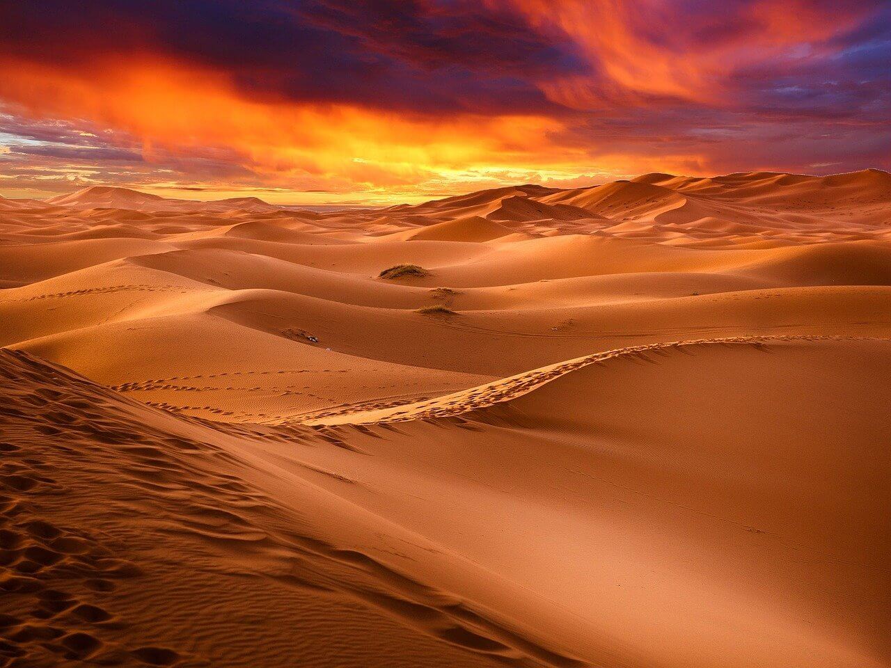
So far as major types are concerned, there are two principal kinds of dry deserts. These are the mountain and bolson desert, and the hammada (or hamada) and erg desert. On each of these major types of surface there are distinctive detailed landforms.
Mountain and Bolson Desert:
A mountain and bolson surface is characterized by a series of hill or mountain ranges separated by broad basins, called bolsons, like the surface of the Great Basin of the United States, particularly in Nevada and Utah. In South America, the Peruvian desert, the Atacama Desert in Chile, and the Bolivian plateau are mountain and bolson deserts. In such a desert, rainfall is greatest in amount and more frequently on the mountain ranges. Because the falls are usually of the cloudburst type and because of the steep slopes, most of the water runs rapidly off the mountains and down into the bolsons. Thus, the mountain slopes are cut by ravines and gorges, and weathered rock material is moved along them into the bolson. When the stream reaches the bolson, the slope of its bed is decreased, and its ability to carry the rock materials is therefore lessened. Consequently, there is built up at the foot of the mountain and at the margin of the bolson a deposit sloping gradually down from the mountain front—an alluvial fan. Very gradually, over a long period of time, the fan grows along the mountain face and toward the center of the bolson. Where many mountain torrents lead down into one bolson, that bolson may eventually be filled as the mountains are worn down.
During and for a short time after a cloudburst, streams may reach across the fans to spread water over the lowest part of the bolson, forming a temporary shallow lake. The water soon evaporated, however, and there remains a white deposit of salts. This is known as a playa, or salt flat. If a sufficiently large number of streams carry water to the bolson, and at least some of it is derived from a reliable source in better-watered mountains, a permanent shallow salt lake, like Great Salt Lake in Utah, is formed. The saltiness of the lake results from the fact that it has no outlet, and the salts are concentrated under constant strong evaporation of water from the lake’s surface.
Hammada and Erg Desert:
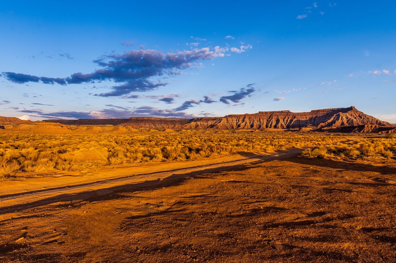
Hammada and erg deserts present striking contrasts to mountain and bolson deserts. Hammada is rocky desert, and erg is sandy desert; the names “hammada” and “erg” are Anglicized forms of the Berber terms for such features in the western Sahara. Extensive rocky surfaces of generally low relief alternate irregularly with relatively smaller sandy wastes. In every instance, the rocky surfaces lie at higher elevations than the sandy areas. Often hammadas represent nearly horizontal layers of resistant rock, but sometimes they are erosion surfaces of domed rocks of varying resistance. With this kind of structure, less resistant rocks are worn away, leaving more resistant layers standing as asymmetric ridges, or cuestas. Facing inward toward the center of doming, the surface is a cliff; away from the center the slope is gradual. If erosion proceeds far enough to expose a very resistant crystalline core at the center of the dome, isolated craggy mountains may stand up prominently above the general level of the hammada. To these the descriptive name inselberge, or island mountains, is given. Often, too, fragments of the hammada are detached from the edges of the main mass by the erosive force of streams, either permanent or intermittent.
Source: pixabay.com
The remaining mass is flat topped, with cliffs dropping away on all sides and a heavy mantle of rock fragments lying steeply up against the base of the cliffs. This type of landform is known as a mesa; sometimes, if the summit area is small, the remnant is called a butte. On some hammadas where physical weathering is very active, a covering of angular rock fragments of varying size is encountered; this is known as desert pavement. If the fragments are of small size, the surface is spoken of as gravelly desert, or reg. In some instances, the hammada may represent geologically ancient mountains of a former mountain and bolson desert, and erg may represent the bolson completely filled with the detrital material worn from the mountains.
The surface of most hammadas is creased by the usually dry stream channels that have been formed by the torrential runoff following the infrequent storms. The erosive power of the steams, exerted downward, cuts vertical-sided valleys; but since the flow of water is of short duration, the materials that are carried by the flood are dropped on the valley floor. Thus, after the valley has again become dry, the valley floor is seen to be flat. Such trenchlike channels of intermittent streams are known as wadis (as in North Africa) or arroyos (as in southwestern United States). All of them lead from the higher parts of the hammada toward the lower parts of erg. While the erg is reached, the wadi as a distinctive form disappears, for any water reaching the sand quickly sinks below the surface.
Material worn from the hammadas supplies the sand of the erg. The extent of erg is a measure of the size and the degree of erosion of nearby hammadas, and of the number of wadis that lead into it. Wind is the agent responsible for the formation of dunes on the sandy surface. Where winds blow constantly from one direction, dunes arrange themselves in rows at right angles to the wind, with gentler slopes on the windward side and steeper slopes on the lee side. Any individual row of dunes is not continuous over long distances, but rather is a line of sand hills separated by low segments. Usually the rows are arranged en echelon. That is, the highest parts of one row are opposite the lower sections of the adjacent row. Unless checked by vegetation or by human control, the whole dune field tends to migrate leeward. No other detailed landforms characterize areas of erg.
Throughout the whole belt of deserts in northern Africa and Asia, the desert is essentially of the hammada and erg type, only a small part of it being erg. South of the equator in Africa, the Kalahari Desert is almost entirely hammada, as is the desert of Australia. A few areas in North America, such as the Colorado Plateau, and the Patagonian desert in South America, are hamada deserts.
Water:
By far the most important factor for life in the desert is the availability of freshwater. The human population that a desert can support is very closely proportional to the amount of water that can be obtained. This may be (1) groundwater, obtained from wells or, in rare instances, from springs; (2) artesian water, obtained through artesian wells or artesian springs; or (3) river water, obtained from the few streams that flow from mountains to salt lakes in bolsons, or from a so-called exotic river (a river that rises in a humid area and flows across a desert, either into the sea or back into a humid land).
Groundwater:
There is groundwater in most deserts, as there is in most humid lands; but there is less of it, and it usually lies at considerably greater depth below the surface. The supply is occasionally replenished by downward-percolating water after a storm, and there is also some underground seepage from more moist areas adjacent to the desert. In mountain and bolson deserts, even when there is no permanent stream flowing from the mountains to the alluvial fans, groundwater is usually available in the valley bottoms within the mountains and near the apexes of alluvial fans. Wells dug in these locations can usually be depended upon for a permanent, though often small, supply; but the farther one goes from the mountains toward the center of the bolson, the smaller is the supply and the deeper it lies beneath the surface. The water of the playa or salt lake is unsuitable for crops, animals, and human beings because of its saltiness. Where permanent streams issue from the mountains, they may provide a source for irrigation of all except the lower slopes of a fan.
Source: pixabay.com
In hammada and erg deserts, groundwater is most likely to be found in the gravel fill of the wadis and in the hollows between the dunes. Where numerous wadis lead into an erg, the supply from wells dug in the wadi floors may be great enough to support a relatively large population. If floods are not too frequent, a single wadi floor may support a long string of oases, making a green swath across the otherwise brown landscape. The amount of water in an erg depends mostly upon the number of wadis draining into it, the depth of the sand accumulation, and the depth of the hollows between the dunes. The problems involved in digging a well in the loose sand of an erg contrast sharply with those of digging to the same depth in the more firmly packed material on a wadi floor. Hence an erg less frequently supports as large a population as a hammada does. Groundwater springs are occasionally encountered in desert areas, primarily in hammadas, where an abrupt slope of sufficient height intersects the water table (the upper limit of the zone of saturation in the soil).
Artesian Water:
The presence of an artesian structure may provide a water source. An artesian structure requires a system of sedimentary rocks dipping in such a way as to bring a porous layer, like a coarse sandstone, to the surface in a moist climatic area beyond the desert. Overlying the porous layer there must be an impervious stratum. Rain falling on the porous outcrop seeps downward into and along the dip of the rocks and cannot rise to the surface except where the impervious rock layer is broken. Such breaks occur naturally where the rock layers are faulted, so there are natural artesian springs. Many of the Saharan oases receive their water from this source, as do many points in the Australian desert. The impervious layer may also be pierced by drilling to bring water to the surface. The water supply from a groundwater source may thus be increased, or an entirely new water source may be provided.
Streams:
Streams provide the third source of water in the desert. These are of two kinds: exotic streams and permanent streams leading to a salt lake. Exotic streams usually spread out into a maze of small shallow channels; there are shifting sandbars where they enter the desert in poorly defined valleys. Often they continue as multiple-channeled streams, called braided streams. If the valley is sharply defined, they may continue in a single course across the desert. The Niger River in western Africa flows northeastward from the Guinea Highlands out beyond the southern margin of the Sahara. As it enters the desert, it spreads out into many channels and then turns again to the southeast and makes its way back into humid lands, where it resumes a single channel normal to streams in moist areas. In its northward bend through the desert it is an exotic river. The White Nile leaves the moist tropical uplands of Uganda and flows northward into the Sahara. On the nearly flat plain of southern Sudan, it adopts a winding braided course, finding its way sluggishly to a structural valley where it again becomes single channeled as it flows across the desert to the Mediterranean Sea.
Exotic streams have two special characteristics that distinguish them from the streams of moisture lands. They have relatively few tributaries in their courses across the desert, and their volume decreases downstream through evaporation. Many of them, like the Colorado in its canyon section, or the Loa River that crosses the Chilean desert from the Andes to the Pacific, are so deeply trenched below the general level of land and flow in such narrow valleys that they are unusable as a source of irrigation water. Others, like the Nile, flow in wide valleys and offer support for very large groups of human population.
In some mountain and bolson deserts, there are permanent streams that have sufficient volume, when they issue from well-watered mountains, to flow out into large bolsons and provide the water for permanent salt lakes. These streams are fresh and therefore provide usable water, so that along their banks a continuous oasis may stretch from the mountains to the lake. Such are the streams of the Turkestan desert of southwestern Soviet Asia, the Amu Darya and the Sir Darya. These permanent streams perpetuate the Aral Sea.
DESERTS OF COLD
On the Arctic fringe of North America and Eurasia, the long-continued cold produces a situation in which plants grow with great difficulty, if at all. The northern coniferous forest gives way to a stunted growth of miniature trees and bushes, and this, in turn, yields to a mixture of plants such as mosses, sedges, lichens, and a few grasses. This is called tundra. Northward, even the tundra ceases to be continuous, occurring in patches separated by stretches completely devoid of vegetation. To this spottily covered zone, the name desert tundra or cold desert is applied. Beyond the limit of any vegetation, ice covers the land, as in the interior of Greenland. To such an extensive region the name ice desert is sometimes applied.
During most of the year, water is present only in the form of ice and hence is not available to plants. In the short period when temperatures are high enough to allow plant growth, there is usually an excess of water, resulting primarily from poor drainage and low evaporation. Since the surface of much of the tundra is flat, surface drainage is poor, and temperatures are seldom high enough for a long period to bring about thawing of the subsoil and thus allow adequate soil drainage.
Excess quantities of water about plant roots act to impede growth, with much the same results as are encountered where there is too little water. Hence, plants of the cold deserts are xerophytic (structurally adapted to limited supplies of water) as are the plants found in deserts of dryness, but they are xerophytic for different reasons and in different ways from plants of a desert of dryness.
Most of the tundra occurs on the Arctic margins of North America and Eurasia. In addition, long fingers of tundra stretch southward along highland zones. Most of Greenland and a large part of Ellesmere Island to the west are ice covered. Hence there is an appreciable extent of cold desert in the Northern Hemisphere; the total extent of this cold desert area approximates the size of the United States without Alaska and Hawaii.
